
Ausable Chasm
Ausable Chasm from the cabins: the 75-mile drive, the sandstone gorge and Rainbow Falls, the trails, rafting and tubing, 2026 prices and hours, and Keeseville.
Ausable Chasm is a sandstone gorge about two miles long and about 150 feet deep, cut by the Ausable River on its way to Lake Champlain, a mile north of Keeseville. It has been open to visitors since 1870, which makes it one of the oldest attractions in North America. From the cabins it is about 75 road miles by way of Plattsburgh, an hour and three quarters each way, so give it a full day and pair it with Plattsburgh or the lakeshore.
The drive from the cabins
The faster way goes through Plattsburgh. County Route 25 runs north from the cabins toward Malone, where phone maps pick up US 11 on the edge of the village. Follow US 11 east through the village of Chateaugay. About a dozen miles past Chateaugay, NY 190, the Military Turnpike, branches off toward Plattsburgh. Near the city, NY 3 takes you a mile east to the Adirondack Northway, I-87, at exit 37. Go south two exits to exit 35, turn left onto NY 442, Bear Swamp Road, and follow it about three miles to US 9. Turn right, and the chasm's welcome center is about three and a half miles south, at 2144 Route 9. The whole drive is about 75 road miles; allow an hour and three quarters.
The slower way goes through the High Peaks. Take County Route 25 to NY 30, follow NY 30 south past Meacham Lake to Paul Smiths, then NY 86 through Saranac Lake to Lake Placid, about 52 road miles from the cabins. Past Lake Placid, NY 86 runs through Wilmington Notch to Wilmington and on to Jay. There NY 9N heads north through Au Sable Forks to Keeseville, and US 9 takes you the last mile and a half north to the chasm. That way is about 89 road miles, two hours or more without stops. Out one way and back the other makes a loop of about 165 miles. In early fall the fall foliage guide shows how to read the weekly color report, which covers Lake Placid, Wilmington and Plattsburgh.
| From the cabins to | Road miles | Main roads |
|---|---|---|
| Downtown Plattsburgh | About 61 | US 11 and NY 190 |
| Ausable Chasm by way of Plattsburgh | About 75 | I-87 to exit 35, NY 442, US 9 |
| Keeseville | About 75 | The same, then US 9 south |
| Port Kent | About 77 | The same, then NY 373 east |
| Lake Placid | About 52 | NY 30 and NY 86 |
| Ausable Chasm by way of Lake Placid | About 89 | NY 86, NY 9N, US 9 |
In winter, allow extra time and plan to be home early; in mid-December the sun sets at the chasm at about 4:15 p.m. The winter driving guide covers tires, timing and what to carry. The Plattsburgh route starts through Malone, whose own story is told in Malone's history and the House of History.
How the gorge formed
The walls of the chasm are Potsdam Sandstone, about 500 million years old, laid down in the Cambrian period when rising seas spread shorelines across much older rock. The section exposed here is about 520 feet thick and formed on ancient tidal flats. The rock still holds the marks of those flats: ripples, cracks where wet sand dried out at low tide, low domes built up by mats of microbes, and the trails of animals that crawled across the sand. One trail, called Climactichnites, looks like a tire track. Two rock surfaces at the Ausable River dam near Keeseville even carry fossil jellyfish, which almost never survive in rock, and trilobites from elsewhere in the chasm date to the early part of the Late Cambrian.
The gorge itself is young. As the last glacier retreated, an arm of the Atlantic called the Champlain Sea flooded the valley for about 3,000 years. About 10,000 years ago, as the land rose and the sea drew back, an Ausable River much bigger and stronger than today's began cutting down through the glacial debris and into the sandstone, following fractures in the rock. Rainbow Falls first formed farther downstream and has moved upstream ever since, as the river wears back the lip of the falls; geologists call that headward erosion. New York lists the chasm among the state's unique geological features for its potholes, the round holes the river has worn into the rock, and for its waterfall. Below the gorge the river carries on to Lake Champlain at Ausable Point.
Rainbow Falls and the bridges
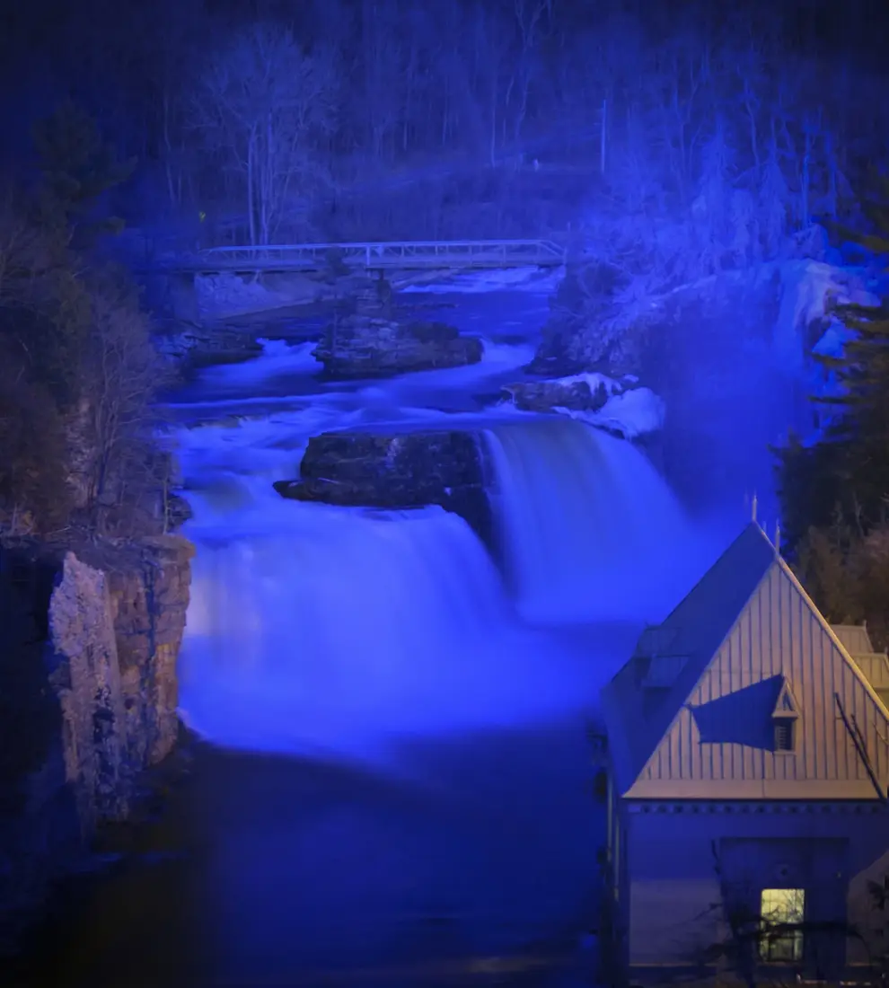
Rainbow Falls drops into the head of the gorge in three steps, just below a dam across the river. Many listings give its height as 91 feet; measured from laser elevation data, the falls themselves drop about 65 feet, and the dam above them stands 15 to 20 feet tall. The best free view is from the US 9 bridge just outside Keeseville, and inside the park the shortest trail, half a mile, goes to Rainbow Falls and Elephant's Head.
That bridge is a landmark of its own. New York's Department of Public Works designed it, Burr M. Stark of Hadley built it, and the New Deal helped pay for it. It opened to traffic in September 1933 and was finished in the summer of 1934. The main span is a single steel arch of 222 feet, about 150 feet above the river, and the approach spans and abutments are faced in granite and the same hard sandstone as the chasm, so the whole bridge looks like masonry. It went on the National Register of Historic Places in 1999.
The steel arch replaced the Old State Road Bridge, a one-lane iron and steel truss of about 1890 that still stands just upstream, over the upper steps of the falls, now closed to cars. The first bridge here was the High Bridge of 1793: two Norway pine logs laid across the gap and planked over. It served for less than 20 years before it fell into the river. Look down from the US 9 bridge and you can also pick out the remains of the railroad bridge of the Peanut, the short line that ran between Port Kent and Keeseville in the early 1900s.
A tourist attraction since 1870
William Gilliland, who came through in October 1765, may have been the first European to see the chasm. He wrote that its cliffs stood on each side like a built wall, 40 to 100 feet high in different places. Settlers soon put the river to work. Sawmills, gristmills, paper mills and wheelwright shops grew up along the Ausable, and each spring loggers rolled pine logs up to 80 feet long into the river at flood level to float them down to Lake Champlain. From the late 1870s until 1910 the Ausable Chasm Horse Nail Works stood on the east bank below Rainbow Falls, ran on the waterfall's power and turned out up to 1,000 tons of nails a year.
Tourists came alongside the factories. The chasm opened to the public in 1870, five years after the Civil War and 22 years before the Adirondack Park was created in 1892. As the mills closed around the turn of the century, visitors became the local industry, and in 1922 the company that ran the chasm built the Ausable Chasm Inn complex. More than 11 million people have visited since it opened.
The rock formations along the way have names, and the guides point them out: Elephant's Head, Column Rock, Hyde's Cave, the Devil's Oven, Table Rock, the Sentry Box, the Broken Needle, Hell's Gate, the Mystic Gorge, the Grand Flume, the Whirlpool Basin and the Inner Sanctum.
The floods of 1996 and 2011
The river that made the chasm can also wreck it. On January 19, 1996, record high water and ice dams uprooted trees as tall as 60 feet, tore steel bridges up to 70 feet long from their footings, ripped steel handrails out of the stone walkways and broke up trailers at a campground a few miles upstream. On November 9, heavy rain brought a second flood that took out everything that had been repaired and more: five of the chasm's ten bridges, fencing, safety rails and a cinder-block building meant for new restrooms, about $500,000 in damage.
The rebuilding changed the visit. New bridges and rails were in place by the next May, on 30-inch steel beams nearly twice as thick as the ones the water took. Instead of only replacing the old route, the chasm cut a new trail system on higher ground, with better views of Elephant's Head and Rainbow Falls. Raft trips replaced the old boat rides, whose 32-foot boats needed just the right water level, and the Rim Walk was to be extended; today the Rim Walk Trail runs two miles.
Fifteen years later Tropical Storm Irene brought record flooding to northern New York on August 28, 2011. Upstream at Au Sable Forks, the Ausable crested more than three feet above its old record. At the head of the chasm the flood swamped the hydroelectric powerhouse at Rainbow Falls, and the powerhouse, its dam and the equipment around them were damaged so badly that the rebuilding ran for years.
The trails
A trail ticket covers about five miles of paths in four parts. Together they pass Rainbow Falls, Elephant's Head, Column Rock, Hyde's Cave and the Mystic Gorge, and the routes into the gorge go down on stone walkways, bridges and stairways through old Adirondack forest.
| Trail | Length |
|---|---|
| Rainbow Falls and Elephant's Head Vista | Half a mile |
| Inner Sanctum Trail | 1 mile |
| Dry Chasm Trail | 1.5 miles |
| Rim Walk Trail | 2 miles |
Plan on at least two hours; with a river trip and a guided tour, a visit can fill a whole day. The park is open from 9 a.m. to 4 p.m. for most of the year and until 5 p.m. from early July to Labor Day, and in spring and late fall, when only the trails are open, you need to arrive by 2 p.m. The walkways are stone and the stairs are many, so wear sturdy shoes with good grip; the trails do not suit anyone with limited mobility. Drones are not allowed anywhere in the park.
Rafting and tubing
The river trip starts at Table Rock, inside the chasm, and runs through the Grand Flume, the narrowest and deepest part of the gorge. It passes the Sentry Box and the Broken Needle, goes through a set of rapids midway and swings around the Whirlpool Basin before an easy run to the landing. On a raft, a guide points out the formations and tells the chasm's history. Tubers ride the same water in helmets and life vests the chasm hands out. At the landing you can hike back to the welcome center or ride the trolley.
Rafting has no minimum age, but riders must weigh at least 30 pounds. Tubing is for ages 8 and up, at least 48 inches tall on a normal day and 54 inches when the river runs high, and under 250 pounds, and tubers need strapped shoes that will not slip off. On a raft, wear shoes you don't mind getting wet, and bring dry clothes for the drive. Rafts and tubes take no reservations, so arrive early: between 11 a.m. and 2 p.m. the wait for a raft can run an hour or more.
The river trips and the trolley run from mid-May to Columbus Day. Tubing is summer only; the 2026 schedule listed it from July 3 to Labor Day, with the last tubes leaving at 3:30 p.m., and it has closed for the season. A ride cost $30 for ages 13 and up, $28 for ages 5 to 12 and $10 for children under 5, on top of trail admission, and each extra ride after the first was $15.
The River Walk and the Adventure Trail
Two guided tours go where the trails do not. The River Walk goes down about 200 steps to a viewpoint beside the river at Rainbow Falls, follows a water-worn path past Elephant's Head and the Devil's Oven, crosses two suspension bridges and ends in the Inner Sanctum. It takes 30 to 45 minutes, is open to ages 5 and up and calls for closed-toe shoes; the chasm supplies the helmets. In 2026 it cost $22 for ages 13 and up and $20 for ages 5 to 12, on top of trail admission.
The Adventure Trail is a guided via ferrata, a climbing route protected by fixed cables. It crisscrosses over the river on cable bridges, with a cargo-net climb and walks along the edges of the walls. You must be at least 8 years old with a reach of 63 inches, weigh 50 to 250 pounds and have a waist of no more than 54 inches, and anyone under 18 needs a parent or guardian along. Hiking shoes or sneakers are required, with no sandals, slip-ons, flip-flops or Crocs, and the harness may not touch bare skin, so leave short shorts and dresses for another day. In 2026 it cost $45 on top of trail admission.
Rappelling and rock climbing are for ages 13 and up, and they are the only activities that must be booked ahead. The two-hour rappelling tour starts with a 30-foot rappel and a 150-foot cable traverse, then finishes with an 80-foot rappel and a 200-foot traverse 130 feet above the river. Climbing sessions last an hour and a half, or three hours for more time on the rock, and a guide belays every climb. The rappelling tour and the 90-minute climb each cost $75 plus adult admission. Both have closed for 2026 and reopen in 2027.
Tickets in 2026
Every visit starts with trail admission, and the packages bundle the rest at a discount. These were the 2026 prices; they change from year to year, so check the current rates before you go. Children under 5 walk the trails free, and the river ride in each package is a raft or, in summer, a tube.
| Ticket | Ages 13 and up | Children | Includes |
|---|---|---|---|
| Trails only | $19.95 | $11.95, ages 5 to 12 | The four trails, about five miles |
| Classic Tour | $49.95 | $39.95, ages 5 to 12 | Trails and a river ride |
| Explorer Package | $54.95 | $44.95, ages 5 to 12 | Trails, a river ride and the River Walk |
| Premium Package | $74.95 | $64.95, ages 8 to 12 | Trails, a river ride and the Adventure Trail |
| Ultimate Chasm Experience | $204.95 | Ages 13 and up only | Trails, a river ride, the Adventure Trail, rappelling and 90 minutes of climbing |
The Classic Tour covers the chasm end to end: about a mile on foot through the chasm, then the river ride, with a shuttle back to the start. From early September the packages were not sold on Tuesdays and Wednesdays, the days the guided tours and rafts did not run. Lockers rent for $5 or $10 with a refundable deposit, which is useful if you are getting wet.
Seasons and hours
The trails are open all year, weather permitting, and everything else follows the seasons. In 2026 the schedule ran like this:
| Dates in 2026 | Hours | What runs |
|---|---|---|
| March 27 to May 14 | 9 a.m. to 4 p.m. daily | Trails only; arrive by 2 p.m. |
| May 15 to July 2 | 9 a.m. to 4 p.m. daily | Trails, rafts, River Walk, Adventure Trail |
| July 3 to September 7 | 9 a.m. to 5 p.m. daily | All of the above, plus tubing |
| September 8 to October 12 | 9 a.m. to 4 p.m. daily | Trails daily; rafts, River Walk and Adventure Trail closed Tuesdays and Wednesdays |
| From October 13 | 9 a.m. to 4 p.m., Monday to Friday | Trails only; arrive by 2 p.m. |
In summer the last Adventure Trail tour left at 3:30 p.m., the last River Walk at 4 p.m., the last tubes at 3:30 p.m. and the last rafts at 4:30 p.m.; from mid-May to early July each left an hour earlier. The chasm closes on Thanksgiving, Christmas Eve, Christmas Day and New Year's Day. From October 13 the chasm's own schedule lists the trails open seven days a week, 9 a.m. to 4 p.m., with a last arrival at 2 p.m.; hours change, so check the schedule or call 518-834-7454 before you go.
Before 2020 the chasm also ran evening lantern tours on the trails, with a campfire and a marshmallow roast on Table Rock inside the gorge. It paused them in 2020, and they are not on the 2026 schedule, so call before you plan an evening around one.
Winter at the chasm
Winter brings the ice. After a few weeks of the right cold, icicles and walls of ice hundreds of feet long form at nine or more places along the two miles of the gorge. The Inner Sanctum Trail and the Rainbow Falls overlook are the places to photograph them, though snow and ice can make the falls hard to see. The chasm offers two ways in.
- Self-guided. The two-mile Rim Walk Trail, for ages 8 and up, at $19.95 for adults and $11.95 for ages 8 to 12. No reservation; buy the ticket at the welcome center.
- Guided. A two-hour tour with a chasm guide, for ages 10 and up, at $54.95 a person. It is the only winter ticket that includes the Inner Sanctum Trail, and the chasm recommends booking it ahead.
On either one you must wear ice cleats or snowshoes. Bring your own or rent a pair at the chasm for $5. Traction is not among the cabins' amenities, so pack it if you own it. In mid-January the sun sets at about 4:40 p.m., so start early, and check the winter days and hours with the chasm before you drive over.
Keeseville
The village a mile south of the chasm grew up on the same river. It was first called Anderson Falls, after an early merchant named John Anderson, and took the name Keeseville around 1812, after the Keese family. The river splits it between two counties: the Town of AuSable in Clinton County on the north bank and the Town of Chesterfield in Essex County on the south. Water power ran its paper and iron works, its lumber and furniture shops, its clothing mills and its horseshoe-nail factories. Keeseville dissolved as a village at the end of 2014, and the two towns now govern it as a hamlet. The photographer William Henry Jackson was born here on April 4, 1843.
The bridges are the reason to stop. The Keystone Arch Bridge on Main Street, a 110-foot sandstone arch built by Solomon Townsend in 1843, is one of the oldest stone arch bridges in the United States and still carries the village's Main Street over the river. Just upstream, the Swing Bridge of 1888 is a footbridge hung from cables, built by the Berlin Iron Bridge Company, and half a mile farther up the river the Upper Bridge, an ornate iron Pratt truss from about 1878, still spans the river. In 1987 the American Society of Civil Engineers named the bridges of Keeseville National Historic Civil Engineering Landmarks, and in 1999 seventeen Ausable River bridges, the steel arch at the chasm among them, went on the National Register together, the first group listing of its kind in the state.
Around the arch bridge, Main and Front Streets keep a historic district of buildings in the same native sandstone: the Ausable Horse Nail Company building of 1847, the Old Brewery of 1850, the Masonic Lodge of 1852 and the Grange Hall of 1856. The Anderson Falls Heritage Society runs a free local museum at 96 Clinton Street, with no stairs to climb, open from late May to mid-October on Thursdays from 10 a.m. to 2 p.m. and Saturdays from 1 to 3 p.m.; donations are welcome, and it is worth calling 518-834-9219 before you go.
Port Kent and the lakeshore
Port Kent is the hamlet on Lake Champlain about three road miles east of the chasm by NY 373. For decades it was the landing for the Lake Champlain Transportation ferry from Burlington, Vermont, and from 1977 Amtrak kept a seasonal platform there for the ferry's passengers. That ferry last sailed in 2019, and in 2026 the company runs only two crossings, Grand Isle to Plattsburgh and Charlotte to Essex. To reach Vermont from here, take the year-round Plattsburgh boat at Cumberland Head, about 19 road miles from the chasm, and for the train use the Plattsburgh station; see getting to the cabins.
About five road miles north of the chasm, the state's Ausable Point Campground runs out into the lake at the mouth of the Ausable River, beside US 9. It has a natural sand beach with a bathhouse, a launch for car-top boats, picnic grounds and 123 campsites, and in 2026 its season ran from May 15 through Columbus Day weekend. It borders the Ausable Marsh Wildlife Management Area, which has a hiking trail and water access for canoes and sea kayaks. In summer it makes a good swim after a hot afternoon in the gorge.
Children, dogs and accessibility
Children under 5 walk the trails free, the River Walk takes them from age 5, and rafting has no minimum age as long as the child weighs 30 pounds. Tubing and the Adventure Trail start at 8, the winter guided tour at 10 and rappelling and climbing at 13. Strollers are not allowed on the trails because of the stairs and narrow walkways; the gift shop rents backpack carriers and front carriers for infants at $15 each, with a refundable deposit. In 2026 the chasm also ran a family scavenger hunt called the Chasm Explorers Challenge. For a family base, see the cabins for families. The cabins themselves are not suitable for children under 10, per their listings' house rules, so a family with small children will need to stay elsewhere for this trip.
Dogs cannot come along. Pets are not allowed on the trails, and service animals are allowed only in the welcome center, café, gift shop and museum and on the Rainbow Falls and Elephant's Head trails. Plan the day around the dog before you go; the dog guide covers what the area allows.
The welcome center, with its café, gift shop and museum, meets ADA standards. The trails do not: the stairs, uneven rock and narrow walkways rule out wheelchairs. For anyone who cannot manage stairs, the view of Rainbow Falls from the US 9 bridge is at road level and costs nothing.
What to bring
- The right shoes. Sneakers or hiking shoes with grip for the trails and the Adventure Trail, closed-toe shoes for the River Walk, and strapped shoes for tubing.
- Dry clothes. Anyone on a raft or a tube will get wet, and the drive home is long.
- Layers and a rain shell. Many activities run rain or shine, but high water and severe weather can stop some of them.
- Lunch. The café in the welcome center is seasonal and serves sandwiches, paninis, burgers and soup. Outside the warm months, pack lunch from the cabin kitchen.
- Traction in winter. Ice cleats or snowshoes, or $5 to rent a pair.
Pairing the chasm with Plattsburgh or the High Peaks
A morning at the chasm leaves the afternoon for something nearby. Plattsburgh is about 13 road miles north on US 9. The War of 1812 Museum on the old air base is about 12 road miles from the chasm, City Beach about 15, and the year-round ferry to Vermont leaves from Cumberland Head north of the city. The Plattsburgh and Lake Champlain guide covers all of it, along with Rulfs Orchard on NY 442, which you pass on the way to the chasm from exit 35.
Going home the High Peaks way puts Lake Placid about 37 road miles from the chasm, with High Falls Gorge and Wilmington Notch along NY 86; see Lake Placid and Whiteface. Hikers can add Poke-O-Moonshine, whose fire tower trail starts on US 9 about 7.5 miles south of Keeseville; it is on the fire tower challenge list. In September, check the events calendar for the Battle of Plattsburgh weekend before you pick a day.
| Time | A summer day |
|---|---|
| 8:00 a.m. | Leave the cabins by way of Malone, US 11 and NY 190. |
| 9:45 a.m. | Arrive at the chasm early, before the midday lines, and buy the Classic Tour. |
| 10:00 a.m. | Walk Rainbow Falls and Elephant's Head, then down into the gorge to Table Rock. |
| 11:00 a.m. | Raft or tube through the Grand Flume, then the trolley back to the welcome center; from 11 the line can take an hour. |
| 1:00 p.m. | Lunch at the café, or drive 13 miles to Plattsburgh. |
| 2:30 p.m. | Plattsburgh's waterfront and museums, or a swim at Ausable Point. |
| 5:00 p.m. | Head home on NY 190 and US 11, about an hour and a quarter from Plattsburgh. |
| 6:30 p.m. | Back at the cabin and into the hot tub, with daylight to spare; the sun sets at about 8:40 p.m. in mid-July. |
Every cabin has its own hot tub; see the cabins.
Questions
How far is Ausable Chasm from the cabins?
About 75 road miles, roughly an hour and three quarters: through Malone, US 11 through Chateaugay, NY 190 toward Plattsburgh, the Northway south to exit 35, then NY 442 east and US 9 south. The High Peaks way, through Lake Placid on NY 86 and NY 9N, is about 89 miles. Go one way and come back the other for a loop of about 165 miles.
How much does Ausable Chasm cost?
In 2026 trail admission was $19.95 for ages 13 and up and $11.95 for ages 5 to 12, and children under 5 walked free. The Classic Tour, the trails plus a raft or tube ride, was $49.95 and $39.95, and other packages added the River Walk or the Adventure Trail. Prices change from year to year, so check the current rates before you go.
Is Ausable Chasm open in winter?
The trails are open all year, weather permitting. From October 13 the chasm's schedule lists the trails open seven days a week, 9 a.m. to 4 p.m., with a last arrival at 2 p.m.; call 518-834-7454 before you go, because hours change. In winter a self-guided walk on the two-mile Rim Walk Trail cost $19.95 for adults, and a two-hour guided tour, the only winter ticket that includes the Inner Sanctum Trail, cost $54.95 for ages 10 and up. Ice cleats or snowshoes are required, and a pair rents for $5.
Can we bring our dog to Ausable Chasm?
No. Pets are not allowed on the trails. Service animals may go only into the welcome center, café, gift shop and museum and onto the Rainbow Falls and Elephant's Head trails. The cabins take pets for a fee, so plan the day around the dog; the dog guide covers what the rest of the area allows.
How old do children need to be for rafting and tubing?
Rafting has no minimum age, but riders must weigh at least 30 pounds. Tubing is for ages 8 and up, at least 48 inches tall, or 54 inches when the river runs high, and under 250 pounds. The River Walk starts at age 5 and the Adventure Trail at 8. Strollers are not allowed on the trails, but the gift shop rents child carriers.
Can you see Rainbow Falls without buying a ticket?
Yes. The US 9 bridge just outside Keeseville looks upstream to Rainbow Falls at the head of the gorge, and the view costs nothing. The bridge is a steel arch from 1933 and 1934, on the National Register since 1999, and the old one-lane truss bridge above the falls, now closed to cars, is in the same view. To walk down into the chasm or ride the river, buy a ticket at the welcome center.
Sources
Facts on this page were checked against these sources in October 2026. Hours, fees and schedules change; confirm before you go.
- ausablechasm.com ausablechasm.com/
- ausablechasm.com ausablechasm.com/packages-rates-hours
- ausablechasm.com ausablechasm.com/scenic-trail-hike
- ausablechasm.com ausablechasm.com/raft-float-tours
- ausablechasm.com ausablechasm.com/river-tubing
- ausablechasm.com ausablechasm.com/classic-tour
- ausablechasm.com ausablechasm.com/river-walk
- ausablechasm.com ausablechasm.com/adventure-trail
- ausablechasm.com ausablechasm.com/rappelling
- ausablechasm.com ausablechasm.com/rock-climbing
- ausablechasm.com ausablechasm.com/winter-tours
- ausablechasm.com ausablechasm.com/visitor-information
- ausablechasm.com ausablechasm.com/frequently-asked-questions
- ausablechasm.com ausablechasm.com/directions
- ausablechasm.com ausablechasm.com/history
- ausablechasm.com ausablechasm.com/discovery-of-ausable-chasm
- ausablechasm.com ausablechasm.com/devastating-floods
- ausablechasm.com ausablechasm.com/historic-bridges
- ausablechasm.rezdy.com ausablechasm.rezdy.com/14848/lantern-tour
- I LOVE NY iloveny.com/listing/ausable-chasm/10812/
- lcbp.org lcbp.org/2025/09/ausable-chasm/
- nysm.nysed.gov nysm.nysed.gov/research-collections/geology/resources/keeseville
- New York State Department of Environmental Conservation dec.ny.gov/regulatory/permits-licenses/seqr/critical-environmental-are
- Lake Placid tourism (ROOST) lakeplacid.com/story/2012/08/adirondack-history-ausable-chasm
- ausableriver.org ausableriver.org/explore/hiking/rainbow-falls
- worldwaterfalldatabase.com worldwaterfalldatabase.com/waterfall/Rainbow-Falls-9219
- keesevillehistoricbridges.com keesevillehistoricbridges.com/ausable-chasm-rt-9-bridge/
- npgallery.nps.gov npgallery.nps.gov/AssetDetail/NRIS/99001320
- historicbridges.org historicbridges.org/bridges/browser/?bridgebrowser=newyork/ausablechas
- New York State Department of Transportation dot.ny.gov/divisions/engineering/design/dqab/css/repository/2001r07.pd
- lakechamplainregion.com lakechamplainregion.com/history/historic-bridges-of-keeseville
- lakechamplainregion.com lakechamplainregion.com/story/2016/12/ausable-chasm-ice-spikes-and-adv
- townofausableny.gov townofausableny.gov/about/town-of-ausable-history/
- andersonfalls.org andersonfalls.org/heritage-house-museum/hamlets/keeseville/
- National Weather Service weather.gov/media/btv/events/Irene2011/Irene2011.pdf
- renewableenergyworld.com renewableenergyworld.com/hydro-power/dams-civil-structures/hydro-revie
- labellapc.com labellapc.com/projects/rainbow-falls-restoration-project/
- Amtrak amtrak.com/stations/prk
- mychamplainvalley.com mychamplainvalley.com/news/local-news/will-the-burlington-ferry-ever-r
- ferries.com ferries.com/
- New York State Department of Environmental Conservation dec.ny.gov/places/ausable-point-campground-and-day-use-area
- rulfsorchard.com rulfsorchard.com/
- api.sunrise-sunset.org api.sunrise-sunset.org/json?lat=44.5247&lng=-73.4615&formatted=0
- router.project-osrm.org router.project-osrm.org/
- ausablechasm.com ausablechasm.com/covid-19
- atlas.lcbp.org atlas.lcbp.org/nature-environment/geology/the-ice-age/
- historicbridges.org historicbridges.org/bridges/browser/?bridgebrowser=newyork%2Foldstate%
- lakechamplainregion.com lakechamplainregion.com/history/anderson-falls-heritage-society-museum
- andersonfalls.org andersonfalls.org/events/
- ferries.com ferries.com/about/history/
- goadirondack.com goadirondack.com/entries/ausable-point-state-park
- ausablechasm.com ausablechasm.com/packages-rates-hours/
In this guide
Stay nearby
The aviation cabin: flight-themed décor, a Jøtul gas stove, a large open deck with its own hot tub, and a smokeless fire pit on the lawn.
 The AviatorCabin 3 · 2 bd · 1 ba · sleeps 4
More in Day Trips
Sources
52 references, listed in full at the end of this guide: official park, state, tourism-office and business sources, checked October 2026.
Related guides



Photos on this page: Santa's Workshop - North Pole NY by Mwanner, CC BY-SA 3.0. Resized and cropped for this site. All photo credits