
Easy Walks and Accessible Trails
Level walks near the cabins and the paths built for wheelchairs, from Malone's paved park loop to the Paul Smith's VIC, the rail trail and the Wild Center.
These are the short, level walks within about an hour and a quarter of the cabins, and the paths built for wheelchairs and strollers, listed nearest first. Malone's recreation park is about ten road miles north, the Paul Smith's College VIC about 30 miles south, and the Saranac Lake Riverwalk and the paved village stretch of the Adirondack Rail Trail about 43. For each one you get the length, the surface, the grade, the parking and the restrooms as the people who run each place, or the local tourism office, describe them, so you can pick the right walk for your group before you get in the car.
The walks at a glance
| Walk | Road miles from the cabins | Length | Surface | Good for |
|---|---|---|---|---|
| High Falls, Titusville Mountain State Forest | 5 | 1.5 miles round trip | Foot trail over level ground | Steady walkers who want a waterfall |
| Bill King Park, Duane Road | 5 | Short wooded trails to the river | Woods paths | A gentle hour by the Salmon River |
| Malone Memorial Recreation Park | 10 | Paved loop of about a mile | Pavement, plus unpaved trails | A paved walk with public restrooms in the park |
| River View Loop, Malone | 10 | 1.4-mile loop | Village streets and bridges | An hour or two downtown |
| Paul Smith's College VIC | 30 | 0.6-mile Barnum Brook loop; 900-foot Heron Marsh boardwalk | Crushed stone and boardwalk | Slower walkers; benches and accessible restrooms |
| Bloomingdale Bog | 40 | Up to about 3.8 miles each way | Old railroad bed | A level out-and-back of any length |
| Saranac Lake Riverwalk | 43 | About a mile round trip | Brick pavers | Step-free at both ends: a ramp at one, a flush sidewalk at the other |
| Adirondack Rail Trail, Saranac Lake | 43 | Two paved miles in the village | Pavement, then compacted stone dust | Wheelchairs and strollers |
| Brewster Peninsula, Lake Placid | 52 | Trails of 0.4 to 0.9 mile | Woods trails | Walkers who can handle roots and rocks |
| Mirror Lake loop, Lake Placid | 53 | 2.7-mile loop | Paved path and sidewalk | An easy long walk with benches |
| The Wild Center, Tupper Lake | 57 | Quarter-mile paved path to the Wild Walk; 1-mile Fen Trail | Pavement and compacted gravel | Wheelchairs, with free loaner chairs and scooters |
Distances are road miles from the cabins. The sections below give the details, and the last ones cover the DEC fishing piers and campgrounds, views you can reach with almost no walking, bugs, winter and who to call before you go.
How to read the word accessible
On this page a path is called accessible only where the agency, college or museum that runs it, or the local tourism office, uses that word. Everything else is described by its surface and grade, so you can judge it against your own chair, walker, stroller or knees.
The state's Department of Environmental Conservation, DEC for short, keeps an online map of its accessible recreation destinations. When the map went live in June 2024 it listed 266 places across New York with wheelchair-accessible features, among them 84 with accessible boating, 58 with accessible fishing and 44 with accessible camping, and DEC finished more than $5 million in accessibility upgrades at the same time. Weather wears these places down, and DEC notes that some may for a while fall short of the standard they were built to, so a quick call before a long drive is worth it. The rail trail's visitor pages make a similar point: the stone dust suits wheelchairs with outdoor tires, and some stretches go soft after heavy rain.
The hiking guide has a table matching each local hike to a kind of group, from first-timers to experienced hikers; this page takes the easy end of that table and goes into it in detail.
At the cabins
The cabins are log cabins on wooded, unpaved properties. There are steps up to the decks and the front doors, and each private hot tub is reached from its cabin's deck. The listings show free parking on the premises, and The Modern Pine and The Aviator share one gravel drive. At The Modern Tiny Home the trails and the observation deck over the pond are a short hike from the cabin, and they are shared with the neighboring cabin when it is occupied. The Modern Pine's and The Modern Tiny Home's backyards are not fully fenced. Each cabin has a main bedroom, a bunk room and one bathroom.
The cabins have not been audited for wheelchair access, and the host would rather describe them as they are than overstate it. The accessibility statement explains how to ask before you book: tell the host what you need and you will get a description of the specific cabin, with the steps at the entrance, door widths where they can be measured, the bathroom layout, the bunks and the parking surface. The cabin comparison shows the three side by side, and you can reach the host through the contact page.
Short walks south of Malone
Chasm Falls
The closest waterfall to the cabins needs no trail at all. Chasm Falls is beside the county road in the hamlet of Chasm Falls, about 2 road miles away, and the Salmon River guide explains where to stop and look.
High Falls in the Titusville Mountain State Forest
High Falls is the easiest trail in the state forest next door, about 5 road miles from the cabins. It is a 1.5-mile round trip over level ground that takes one to two hours, following blue markers past small falls to a curtain-slide waterfall with a 30-foot drop. The drive in ends on Barnesville Road, a gravel road, at a small parking spot on the right about 0.7 mile along, near a closed bridge.
It is a foot trail through the woods, so it suits steady walkers and children 10 and up. None of the forest's three trails works for a wheelchair: Elephant's Head has a wooden staircase near the top and the Ledges are steep rock. The Titusville Mountain State Forest guide covers all three.
Bill King Park
Bill King Park sits on the Salmon River beside Duane Road, County Route 25, about 5 road miles from the cabins and 3.1 miles south of the Malone Golf Club. Its parking area is marked with round stones from the old mills that once ground local grain into flour. Wooded trails lead from the lot through the trees to the river, a gentle walk of one to two hours, and the river views are the reason to go. It makes an easy first outing on the afternoon you arrive.
Malone Memorial Recreation Park
The village park on Duane Street is on your way into Malone from the cabins, about 10 road miles and 20 to 25 minutes north, and it has the nearest paved path to the cabins. A paved recreation trail makes a loop of about a mile, and the park also has unpaved woods trails and a waterfront walkway by Rotary Lake. There are public restrooms, a pavilion, a gazebo, picnic tables and playgrounds, and the park has plenty of daytime parking.
With public restrooms and plenty of parking in the park, the loop makes an easy first outing, and a good test of a new walker or a borrowed chair before a longer day out. In fall thousands of snow geese and Canada geese come down on Rotary Lake each day, and the lakeshore is the place to watch them. The Salmon River guide has more on the park, the new pool and the geese, and the wildlife guide has the timing of the migration.
Walking the river in Malone
Downtown, the River View Loop is a 1.4-mile walk on village streets with three crossings of the Salmon River, starting at East Main and Pearl streets. Allow one to two hours. The Salmon River guide gives the turn-by-turn route, and the town guide has lunch and coffee nearby.
Anglers who use a wheelchair have a spot in the village too: DEC lists the Salmon River at the Ballard Mill hydro project among its fishing sites with access for people with disabilities. The Ballard Mill, home of North Country Community College's Malone campus, is about 10 road miles from the cabins.
Paul Smith's College VIC
The Paul Smith's College Visitor Interpretive Center, the VIC, is a good first choice for a group with mixed abilities, with short loops for some and longer trails for others. It sits on NY 30 at Paul Smiths, about 30 road miles and 45 minutes south, on a 3,000-acre property with more than 25 miles of trails. The trails are open from dawn to dusk every day. In the fall of 2026 the lodge is open from 9 a.m. to 5 p.m., Thursday through Monday; check the VIC's website before you go. The Frank M. Hutchins Lodge has accessible restrooms, listed as open 24 hours.
Barnum Brook
Barnum Brook is the VIC's shortest and gentlest loop, 0.6 mile on a crushed-stone base. It starts at a gazebo near the visitor center parking lot and runs through second-growth forest to two overlooks, one over Heron Marsh and one toward St. Regis Mountain. The overlook facing the marsh and its beaver lodge is built to be accessible. From there the trail follows Barnum Brook on a boardwalk, crosses a fish barrier dam and comes back to the gazebo through a stand of eastern white pines. The grades are slight and there are many benches along the way.
The trail was designed for people who have trouble walking. It is not considered generally wheelchair accessible: the surface changes between boardwalk with edge barriers and partial railings, pavement, gravel and natural ground, and the boardwalk is slippery when wet. If you use a wheelchair, call or ask at the lodge before you set out; the staff know the current state of each section.
Heron Marsh and Easy Street
The Heron Marsh boardwalk is flat and accessible, 900 feet of boardwalk across the marsh. The full Heron Marsh loop is 3 miles with a few moderate hills, so ask at the lodge for the shortest way out to the boardwalk. Easy Street, a 1-mile loop past the college's working sugarbush, is flat, wide and smooth. The Boreal Life loop crosses a black spruce bog on a 1,600-foot boardwalk. The VIC's snowshoe trails, which are hiking trails in summer, range from smoothly graded nature trails to rocky, rooty footpaths.
Changes coming
In March 2026 the college received a $35,264 grant from DEC's Adirondack Park Community Smart Growth Program to study access across the VIC, indoors and out, and it plans to rebuild Barnum Brook as a regional model for accessible outdoor recreation. Since 2024 the VIC has also hosted a yearly Adirondack Nature Festival for People with Disabilities. Dogs are welcome on a leash all year; sign in and clean up after them.
Nearby on Keese Mill Road, DEC lists a small dock at the Black Pond outlet as an accessible fishing spot. The Saranac Lake and Paul Smiths guide has the full trail table, the VIC's programs and lunch at the college.
Bloomingdale Bog
The Bloomingdale Bog trail follows the bed of the old Delaware and Hudson railroad between Saranac Lake and Bloomingdale, so it is wide, level and mostly straight. The stretch from the parking area off NY 86 north to the Bloomingdale-Gabriels road, County Route 55, is 3.7 to 3.8 miles, with less than 25 feet of climbing one way. Walk in as far as you like and turn around.
The south trailhead is about 40 road miles and under an hour from the cabins. From downtown Saranac Lake it is about 2.5 miles out NY 86 toward Paul Smiths: look for a black silhouette of a man on a tractor on the right, beside a dirt road, and follow the road to a parking area by a yellow metal gate and a brown and yellow DEC sign. This end is prone to flooding, and beaver work shows up after about a mile. The north end, at a pull-off with a yellow gate off County Route 55, is smooth enough for strollers with big tires, with open tamarack stands and gray jays, and Two Bridge Brook about a mile in makes a good turnaround.
The trail pages list no restrooms at either end, so plan a stop at the VIC lodge or in Saranac Lake. The Saranac Lake and Paul Smiths guide covers the birds and plants of the bog.
Saranac Lake Riverwalk
The Riverwalk follows the Saranac River through downtown Saranac Lake on a brick-paved path, about a mile round trip, crossing the water on several bridges and passing cafés, bakeries and shops along the way. It is about 43 road miles from the cabins, about an hour's drive.
Both ends have step-free access. At one end there is a ramp behind the town buildings: turn left at the Main Street traffic light and take the next right into the parking lot. At the other end, by the Tops Market on Church Street, the sidewalk is flush with the parking lot. Curb cuts take you across the streets in between. The entrance from the Dorsey Street parking lot is by covered staircases, so use one of the ends with a chair or a stroller. Its two street addresses are 3 Main Street and 156 Church Street.
The Riverwalk pairs with the paved rail trail and with Berkeley Green, the small park at Main Street and Broadway where the Saranac Lake 6er bell hangs, all close together in the village.
The Adirondack Rail Trail in Saranac Lake
The rail trail runs 34 miles on the old railroad bed from Lake Placid to Tupper Lake, and DEC planned the whole length to be wheelchair accessible. Its typical slope is 2 percent and its steepest is 5 percent, the tread is typically 5 feet wide, and the surface is firm compacted stone dust except for the two miles inside the Village of Saranac Lake, which are paved. Walkers, wheelchairs and strollers are all welcome, and dogs go on a leash no longer than 6 feet.
Wheelchair access from parking is at two lots: the Union Depot on Depot Street in Saranac Lake, about 43 road miles from the cabins, and Fowler's Crossing on NY 86 east of the village. For a first try, start at the Union Depot and roll out along the paved village section of the Adirondack Rail Trail, then turn around whenever you like.
Lake Placid
The Mirror Lake loop
The walk around Mirror Lake in the middle of Lake Placid village is 2.7 miles on a paved path and sidewalk, about 53 road miles and an hour and a quarter from the cabins. The brick-colored pavers along Mirror Lake Drive were redone before the 2023 World University Games. A good place to start is the Toboggan Chute on Parkside Drive, where a sign shows the whole loop on a map, with a public beach, a playground and tennis courts beside it; you can also park on Main Street. Benches along Mirror Lake Drive look out over the village and the mountains, and gray plaques along the way give the names and heights of the 46 High Peaks. The state boat launch is at the north end of the lake and the sandy public beach at the south end.
Halfway down Main Street, Mid's Park is a sloping lawn that runs down to the water, a pleasant place to sit if the full loop is too far. The Lake Placid day trip guide has the rest of the village.
Brewster Peninsula
The Peninsula Nature Trails cover 133 acres of state land on the shore of Lake Placid, the big lake beside the village, bought by the state in 1960. To find them, follow NY 86 through the village toward Saranac Lake and turn right where a large DEC sign for the trails marks what looks like a hotel entrance. Bear left at the next intersection, and the dirt road brings you to a small dirt parking area on the left. There are four trails. The Corridor Trail, about 0.75 mile on an old road, dips slightly to the trail register and then levels out. The Boundary Trail, 0.9 mile, is fairly flat. The Lake Shore Trail, 0.4 mile, follows the water to a dam and is rockier and more uneven than the rest, and the Ridge Trail climbs steadily. In 2002 fourteen interpretive signs by the naturalist and illustrator Sheri Amsel went up along the old road and the shore. These are woods trails for walkers, a quiet hour away from the village sidewalks; sign in and out at the register.
The Wild Center
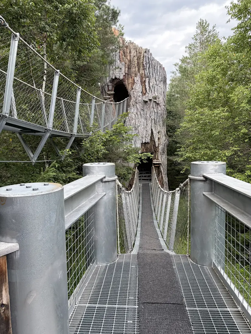
The Wild Center, the natural history museum in Tupper Lake about 57 road miles from the cabins, publishes detailed access information. From the main parking lot a paved path built to accessibility standards leads to the Wild Walk, most of the Wild Walk is built to the same standards, and the eagle's nest at its far end is about a quarter mile from the lot. The Fen Trail is a 1-mile loop of compacted gravel with gentle grades and a few slight inclines, and the gravel path around Greenleaf Pond is accessible too. Forest Music, a quarter-mile loop, is accessible, though its surface and terrain can be hard going for some visitors, and the trail to the Oxbow on the Raquette River is not accessible.
Visitor Services lends manual wheelchairs, walkers and motorized scooters free, first come, first served, along with strollers and wagons for children. Only service animals are allowed on the campus. Rain, snow and ice change the trail surfaces, so take care in wet weather. The Wild Center guide has the hours, the timed tickets and the café.
DEC fishing piers and campgrounds
Several of DEC's accessible sites near the cabins are built for fishing and camping, and they make an easy afternoon by the water.
- Meacham Lake Campground, about 21 road miles and 35 minutes south on NY 30. DEC finished new accessible bathrooms here in 2024. The east-shore boat launch has a concrete ramp with docks designed for people with disabilities, and one of its 21 parking spaces is reserved; the old launch has an accessible trailer space. DEC lists the campground's closing date as October 12 and its opening as May 15, so plan this one for late spring to early fall and check the dates with DEC. The Meacham Lake guide covers the lake.
- Grass Pond and Fishhole Pond, Sable Highlands, about 20 road miles away on County Route 26. DEC lists two fishing piers for anglers with disabilities on the Sable Highlands conservation easement, one at Grass Pond and one at Fishhole Pond, and has built a wheelchair-accessible ramp to Grass Pond from a parking area on County Route 26. Driving north on County Route 26 from NY 3, the Grass Pond parking area is on the right about 7.2 miles along, with a short boardwalk to the water. The Sable Highlands guide covers the easement lands.
- Fish Creek Pond Campground, on NY 30 north of Tupper Lake, about 48 road miles away. It has 11 accessible campsites, a fishing dock in the day-use area with lowered sections of railing for wheelchair anglers, and accessible toilets in the day-use area; the accessible showers are at Rollins Pond Campground next door. About 0.6 mile of the campground's pond trail is paved.
- Indian Carry, on NY 3 about 8 miles east of Tupper Lake village, about 55 road miles away, with fishing access, parking and a path to a dock on Upper Saranac Lake.
A New York fishing license is needed from age 16. In 2026 a one-day license cost $5 for residents and $10 for nonresidents, and November 11 is the year's last free fishing day, when no license is needed. Confirm these sites with DEC's Region 5 office before a trip.
Views with almost no walking
For anyone who cannot manage a trail at all, a few big views are reached by car. The Whiteface Veterans Memorial Highway climbs Whiteface Mountain above Wilmington, about 59 road miles from the cabins to the castle at the top, and from there an elevator carved deep into the mountain, fully accessible, carries you to the summit when it is running. The Alpine Nature Trail to the summit, about a fifth of a mile, is steep, can be slippery and is not wheelchair accessible. The highway is open daily from 8:45 a.m. to 5:30 p.m. in season. In 2026 it opened May 15 and closes October 12, and it usually reopens in mid-May. Whiteface's conditions report shows whether the summit elevator is running that day. Admission is included in the Lake Placid Legacy Sites summer passport.
Closer to home, Chasm Falls is a roadside stop 2 miles from the cabins, and from the small overlook at the east end of the Main Street bridge in Malone you look down on the Salmon River, the dam and the old gristmill.
Benches, shade, bugs and ticks
- Benches. Barnum Brook at the VIC has many benches, Mirror Lake Drive has benches facing the mountains, and the recreation park in Malone has a pavilion, a gazebo and picnic tables. The bog and the rail trail are long, so bring a folding stool if someone needs to rest often.
- Shade and sun. Bloomingdale Bog alternates wide views with stretches of dense boreal forest, and the Heron Marsh boardwalk crosses open marsh. Bring hats and water on a sunny day.
- Black flies. They are out from about mid-May to mid-June, sometimes into early July, at their worst in late May and early June, mostly from 9 to 11 a.m. and 4 to 7 p.m., and near moving water. In those weeks, plan the longer walks for the middle of the day.
- Ticks. Blacklegged ticks are found here, and the young nymphs, the hardest to see, peak in May and June. Stay on the path, tuck long pants into socks on grassy trails and check everyone, dogs included, back at the cabin.
- Wet boardwalks. The boardwalk along Barnum Brook at the VIC is slippery when wet, and the Wild Center asks for care on its paths in rain, snow and ice. Shoes with a good grip help everyone.
The bugs, ticks and black flies guide has what works against each one.
Easy walks in winter
January in Malone averages a high of 23°F and about 22 inches of snow, and the easy walks change with it. From about December 1 to April 1 the VIC grooms its trails for cross-country skiing, Easy Street and Barnum Brook among them, and a day or season trail pass is required; snowshoers are welcome and are asked to stay out of the set ski tracks. The rail trail's winter users are snowmobiles, skiers, snowshoers and fat-tire bikes, so a winter outing there means sharing with sleds. Bloomingdale Bog is a favorite local ski and snowshoe route and can be busy on a fine winter day.
In winter the easiest walks are the village sidewalks of Malone, Saranac Lake and Lake Placid, and the Wild Center, which has opened Friday through Sunday in recent winters and lit its grounds for Wild Lights evenings; check its winter schedule before you go. Pack traction cleats for icy sidewalks and keep the car warm between stops. The cross-country skiing and snowshoeing guide covers the VIC's passes and rentals, and the winter driving guide covers the roads.
An easy day from the cabins
This day keeps every walk short, with the VIC's restrooms in the morning and lunch in town at midday, and it works best Thursday through Monday, when the VIC lodge is open.
| Time | Plan |
|---|---|
| 9:00 a.m. | Leave the cabins by County Route 25 and NY 30 south. |
| 9:45 a.m. | VIC: the lodge restrooms, then Barnum Brook to the marsh overlook and back, or the Heron Marsh boardwalk. |
| 11:30 a.m. | Drive on to Saranac Lake by NY 86, about 13 miles. |
| Noon | Lunch downtown, then the Riverwalk from the ramp behind the town buildings. |
| 2:00 p.m. | The paved rail trail from the Union Depot, out and back as far as you like. |
| 3:30 p.m. | About an hour home by NY 86 and NY 30, with time for the hot tub before dinner. |
A closer half day: Bill King Park in the morning, the recreation park's paved loop before lunch in Malone, and groceries on the way home. The groceries and supplies page lists the stores.
Calling ahead
- Paul Smith's College VIC: 518-327-6241, for trail conditions and the state of the Barnum Brook boardwalk.
- The Wild Center: (518) 359-7800 or Accessibility@wildcenter.org, to talk through your needs before you buy tickets.
- DEC: the accessibility line at 518-402-9295 for questions about access at state sites; the Region 5 fisheries office at 518-897-1333 to confirm the fishing sites; Meacham Lake Campground at (518) 483-5116 in season.
- Saranac Lake: the village office at (518) 891-4150 about the Riverwalk.
- The cabins: the host, through the contact page, for steps, doors and the bathroom at the cabin you have in mind.
Dogs are welcome on a leash at the VIC and on the rail trail, and only service animals are allowed at the Wild Center; the dog guide has the rest. When you are ready to choose a cabin, the cabins page has all three.
Questions
Can someone who uses a wheelchair stay at the cabins?
The cabins have not been audited for wheelchair access. They are log cabins on wooded, unpaved properties with steps up to the decks and front doors, and the hot tubs are on the decks. Before you book, tell the host what you need and you will get a description of the specific cabin; the accessibility statement explains how.
What is the closest paved walk to the cabins?
Malone Memorial Recreation Park on Duane Street, about 10 road miles north on the way into town. Its paved recreation trail makes a loop of about a mile, and the park has public restrooms, a pavilion, picnic tables and plenty of daytime parking.
Which trails at the Paul Smith's College VIC work for a wheelchair?
The VIC calls its Heron Marsh boardwalk flat and accessible, and Barnum Brook has an accessible overlook of the marsh. Barnum Brook itself mixes boardwalk, pavement, gravel and natural ground, so it is not generally rated for wheelchairs. The lodge has accessible restrooms open 24 hours; call 518-327-6241 for current conditions.
Can I borrow a wheelchair at the Wild Center?
Yes. Visitor Services lends manual wheelchairs, walkers and motorized scooters free, first come, first served, in limited numbers. A paved path built to accessibility standards leads from the main lot to the Wild Walk, about a quarter mile to the eagle's nest. The Wild Center guide has hours and tickets.
Is the Adirondack Rail Trail paved?
Only the two miles inside the Village of Saranac Lake. The rest of the 34 miles is firm compacted stone dust, with a typical slope of 2 percent and a maximum of 5. Wheelchair access from parking is at the Union Depot in Saranac Lake and at Fowler's Crossing on NY 86.
Where can an angler in a wheelchair fish near the cabins?
DEC lists accessible fishing on the Salmon River at the Ballard Mill in Malone, piers at Grass Pond and Fishhole Pond in the Sable Highlands, a dock at the Black Pond outlet near Paul Smiths, and a dock at Fish Creek Pond Campground. Confirm each with DEC's Region 5 office at 518-897-1333 before you go.
Are there easy walks in winter?
The village sidewalks of Malone, Saranac Lake and Lake Placid are the simplest, and the Wild Center has opened Friday through Sunday in recent winters. The VIC grooms its trails for skiing from about December 1 to April 1 and requires a trail pass, and the rail trail is shared with snowmobiles. Pack traction cleats.
Sources
Facts on this page were checked against these sources in October 2026. Hours, fees and schedules change; confirm before you go.
- New York State Department of Environmental Conservation dec.ny.gov/places-to-go/accessible-recreation/destinations
- New York State Department of Environmental Conservation dec.ny.gov/news/press-releases/2024/6/dec-announces-accessible-outdoor
- wcax.com wcax.com/2024/06/07/ny-dec-unveils-new-accessibility-features/
- New York State Department of Environmental Conservation dec.ny.gov/things-to-do/freshwater-fishing/places-to-fish/adirondack-l
- adirondackrailtrail.org adirondackrailtrail.org/about-us/faqs/
- apa.ny.gov apa.ny.gov/meeting/2025/09/files/state-lands/DECRailTrail.pdf
- Visit Malone visitmalone.com/hiking/high-falls-titusville-mountain
- Visit Malone visitmalone.com/hiking/bill-king-park-trails
- Visit Malone visitmalone.com/hiking/river-view-loop
- Visit Malone visitmalone.com/parks/malone-memorial-recreation-park
- Franklin County tourism (Always Franklin) alwaysfranklin.com/listing/malone-memorial-recreation-park
- New York State Department of Environmental Conservation dec.ny.gov/places/titusville-mountain-state-forest
- Paul Smith's College paulsmiths.edu/vic/
- Paul Smith's College paulsmiths.edu/vic/explore/
- Paul Smith's College paulsmiths.edu/vic/facilities/
- Paul Smith's College paulsmiths.edu/wp-content/uploads/2024/11/VIC-map-2021.pdf
- wildadirondacks.org wildadirondacks.org/barnum-brook-interpretive-trail.html
- adk.corsizio.com adk.corsizio.com/event/69e23378f7da8b6bc2705979
- Paul Smith's College paulsmiths.edu/news/paul-smiths-college-receives-smart-growth-grant/
- Saranac Lake tourism saranaclake.com/hiking/bloomingdale-bog-trail
- New York State Department of Environmental Conservation extapps.dec.ny.gov/docs/lands_forests_pdf/dhhikingmap.pdf
- Saranac Lake tourism saranaclake.com/nature-and-historic-walks/saranac-lake-riverwalk
- saranaclakeny.gov saranaclakeny.gov/riverwalk-1/
- Lake Placid tourism (ROOST) lakeplacid.com/hiking/peninsula-nature-trails
- wildadirondacks.org wildadirondacks.org/peninsula-nature-trails.html
- Lake Placid tourism (ROOST) lakeplacid.com/story/2010/10/walk-around-lake-placids-mirror-lake
- Lake Placid tourism (ROOST) lakeplacid.com/story/2017/08/four-views-you-can-walk
- The Wild Center wildcenter.org/accessibility/
- Saranac Lake tourism saranaclake.com/campgrounds/meacham-lake-campground
- New York State Department of Environmental Conservation dec.ny.gov/places/meacham-lake-campground-and-day-use-area
- Saranac Lake tourism saranaclake.com/story/2022/accessible-features-at-fish-creek-campgroun
- Adirondack Explorer adirondackexplorer.org/stories/the-loon-lake-challenge-paddling-four-p
- Lake Placid tourism (ROOST) lakeplacid.com/attractions/whiteface-veterans-memorial-highway
- orda.org orda.org/?p=5101
- tupperlake.com tupperlake.com/adirondack-rail-trail
- New York State Department of Environmental Conservation dec.ny.gov/about/accessibility-for-persons-with-disabilities
- Adirondack Explorer adirondackexplorer.org/?p=253890
- Adirondack Explorer adirondackexplorer.org/?p=307595
- Whiteface Mountain (ORDA) whiteface.com/todo/whiteface-veterans-memorial-highway/
- Whiteface Mountain (ORDA) whiteface.com/mountain/conditions/
- Olympic Regional Development Authority lakeplacidlegacysites.com/summer/
- The Wild Center wildcenter.org/visit/wildlights/
- New York State Department of Environmental Conservation dec.ny.gov/get-involved/events/2026/11/free-fishing-day-statewide
- takemefishing.org takemefishing.org/new-york/fishing-license/
In this guide
Stay nearby
The first of the cabins: a big stone fire pit you see as you walk up, a screened corner of the deck, direct trail access, and a short walk to an observation deck over the pond.
 The Modern Tiny HomeCabin 1 · 2 bd · 1 ba · sleeps 4
More in Trails & Hiking
Sources
44 references, listed in full at the end of this guide: official park, state, tourism-office and business sources, checked October 2026.
Related guides


Photos on this page: Wild Center 01 by Dclemens1971, CC BY 4.0. Resized and cropped for this site. All photo credits